With plenty of promise, the third launch of Europe’s Galileo constellation took place four years ago. What followed was not at all what was expected, as problems turned much of the promise into gloom.
Unusually low power and instability in the radio signals received from the two satellites at the telemetry stations operated by the European Space Agency (ESA), the French National Space Agency (CNES) and the Swedish Space Corporation (SSC) showed that the satellites were not in their expected orbit. What followed, however, was a variety of procedures that led to the mission recovery and returned promise to the program.
Here, the authors explain how Galileo satellites 5 and 6, which were almost considered lost, put under test the ingenuity of the many engineers involved in the recovery of this mission demonstrating the technical excellence and collaborations with experts from various institutions, space agencies and industrial partners. The third launch of the Galileo constellation took place on August 22, 2014 by Soyuz ST-Fregat vehicle from Europe’s Spaceport in French Guiana, carrying Europe’s fifth and sixth Galileo satellites. These were the first series being built by OHB System AG, the company selected to complete the Galileo constellation. Due to a malfunction of Soyuz Fregat upper stage, the satellites were injected into a lower and elliptical orbit instead of the planned circular orbit and with only one out of the two solar array wings deployed on both spacecraft. As a result, the satellites were left in non-nominal orbit leading to exposure to the Van Allen radiation belts, non-nominal operation of the Earth Sensors and insufficient fuel to correct the orbits entirely. The prospects for the mission were gloom to say the least, however very quickly, experts across European institutions, space agencies and industrial partners joined forces to recover the satellites and to investigate possible operational scenarios. What followed was the history of one of the most remarkable successes in the recovery of a failed launch. This success has already allowed to put these satellites in use for search and rescue services and for an ambitious test of Einstein’s General Theory of Relativity. This article is the first in a series on the extraordinary journey of Galileo satellites 5 and 6 from launch to mission recovery and exploitation. Ultimately, the final stage will bring these satellites into service for navigation usage.
The Mishap
At the beginning everything seemed well, but then the Galileo’s Launch and Early Orbit Phase (LEOP) team at the European Space Operations Centre (ESOC) in Darmstadt, Germany, responsible for controlling the satellites, raised the alarm. Unusually low power and instability in the radio signals received from the two satellites at the telemetry stations operated by the European Space Agency (ESA), the French National Space Agency (CNES) and the Swedish Space Corporation (SSC) showed that the satellites were not in their expected orbit. The satellites were left in an elliptical orbit with the apogee at 25,900 kilometers above Earth and the perigee at 13,713 kilometers, with the orbit wrongly inclined by 49.77º with respect to the equator (Figure 1). The first priority was to ensure the satellites were safe and stable. With one solar wing deployed, there was enough power to ensure spacecraft viability and safety. The second urgent priority was to determine a sufficiently accurate orbit to ensure a proper pointing of the antenna in order to monitor and control the satellites. Within four hours of the first signal reception, the team determined the actual orbit, then generated new commands to repoint the ground antennas and established robust radio links. Over the following few days, with support from ESA’s Galileo project and satellite manufacturer OHB, the LEOP team developed, validated and rehearsed procedures to release the trapped solar wings, boosting the available power to its nominal value as they pointed toward the sun. Both satellites were left in a mode pointing to the sun, but they could not be used for navigation purposes nor be tested as the Earth Sensors used to point their navigation antennas stopped working around perigee because Earth’s disc filled their field of view. 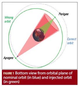 The Independent Inquiry Commission of Arianespace, European Commission (EC), ESA experts and Russia’s Space Agency Roscosmos concluded that the problem was due to a misfiring Fregat upper stage. Corrective measures were performed in the subsequent launches to prevent recurrence of the problem (Figure 2).
Mission Recovery
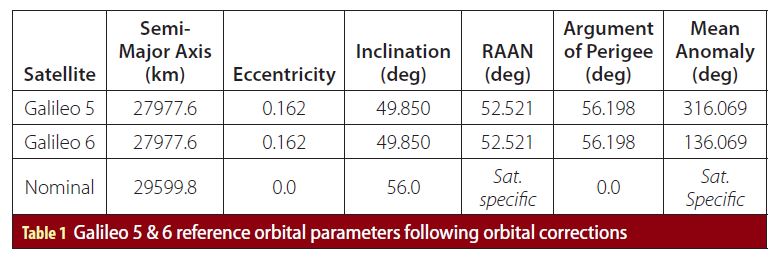
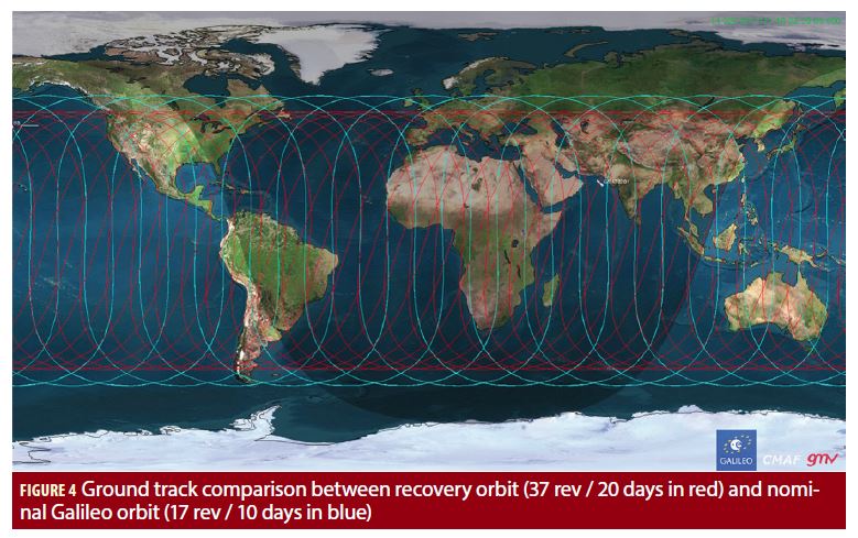
In parallel to the Independent Inquiry Commission, a multidisciplinary team of engineers at ESA initiated a number of mission recovery analysis in order to investigate possible operational scenarios which would allow to restore, as much as possible, the intended mission objectives and maximise the benefits for the program. Given the high eccentricity and low perigee of the injection orbit, the mission drivers for the recovery were to: • Reduce the L-band power dynamic range between apogee and perigee • Reduce Doppler as to facilitate L-band ground receivers to lock the signal • Increase visibility time for receivers • Ensure perigee high enough to allow Earth Sensors to be operational over the complete orbit • Reduce exposure to the Van Allen radiation belts to minimize satellite equipment degradation • Improve contribution to the global constellation performance Different scenarios were prepared by ESA, supported by experts from industry and national space agencies, and proposed to the owner of the satellites, the EC, which gave the “green” light to initiate the recovery actions. 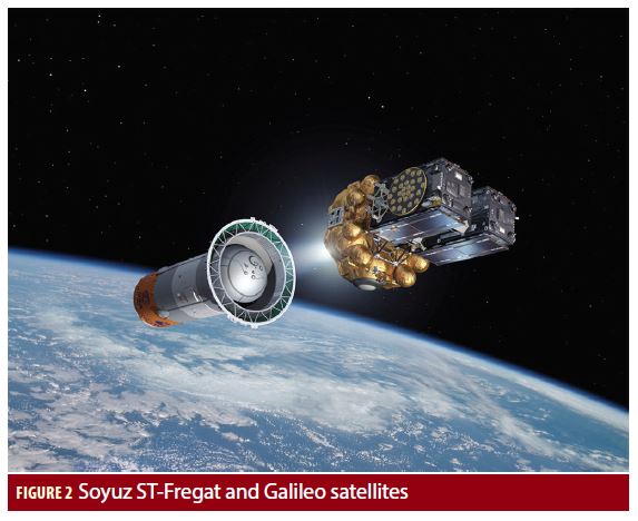 In September 2014, the control of Galileo satellites 5 and 6 was transferred from the LEOP team at ESOC in Darmstadt, Germany to the Galileo Control Centre (GCC) in Oberpfaffenhofen, Germany, operated by SpaceOpal. But the satellites’ incorrect orbits meant their navigation payloads could not be switched on for testing due to the non-nominal operation of the Earth Sensors. In addition, the lower orbits were exposing them to heightened levels of harmful radiation. Limited fuel meant the satellites’ originally assigned destination was out of reach, but their orbits could still be modified to make them suitable for navigation purposes. A recovery plan was devised between ESA’s Galileo team, ESOC flight dynamics specialists, along with personnel from SpaceOpal, OHB with the support of the French (CNES), Italian (ASI), German (DLR) and British (UKSA) space agencies experts. The scheme involved a multiple series of maneuvers, gradually raising the lowest point of the satellites’ orbits more than 3,500 kilometers while making them more circular and positioned 180º of each other. The fifth Galileo entered its corrected orbit at the end of November 2014, followed by the sixth Galileo in March 2015 with a total of 11 and 14 orbit raising maneuvers, respectively. The commands were issued from the Galileo Control Centre at Oberpfaffenhofen, Germany by SpaceOpal, guided by calculations from a combined ESA-CNES flight dynamics team. Commands were uploaded to the satellite via an extended network of ground stations, made up of Galileo stations and additional sites coordinated by CNES. Satellite manufacturer OHB also provided expertise throughout the recovery, helping to adapt the flight procedures. In the new orbit, the satellite’s radiation exposure has also been greatly reduced, ensuring reliable performance for the long term. The corrected orbit of the satellites is shown in Figure 3. The recovery strategy achieved a slightly elliptic orbit due to insufficient fuel in the satellites’ propulsion system to reach the nominal orbit (See Table 1). The major advantage in this slightly elliptic orbit with the two satellites separated by 180º is that the ground track repetition pattern is 37 orbital revolutions in 20 siderial days, with a sub-cycle of 10 days where the two satellites swap locations in the geometry. This is compatible to the nominal Galileo constellation having a repetition pattern of 17 revolutions in 10 siderial days (Figure 4). This allows a proper predictability and repeatability of the constellation and an inclusion of the satellites into the planning functions of the system. The revised, more circular and higher altitude orbit means the satellites’ Earth Sensors can be used continuously, keeping their main antennas oriented towards Earth and allowing the navigation payload to be switched on.
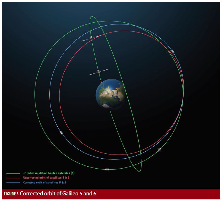
Testing the Signals for Navigation
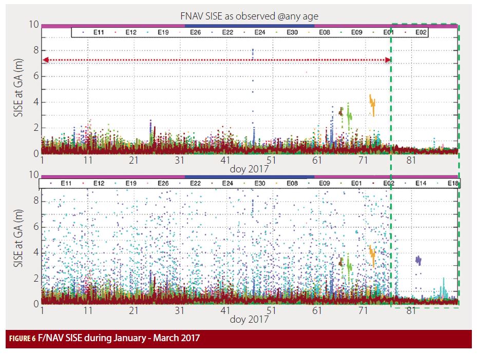
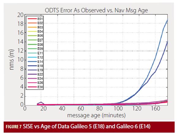
With Galileo 5 and 6 having reached a more suitable orbit for navigation purposes, the In-Orbit Test (IOT) campaign could start and the navigation payloads were switched on. The IOT campaign was conducted from the ESA tracking station in Redu, Belgium, where the satellite broadcast navigation signal was monitored using the 20 meter L-band antenna to study the strength and shape of the navigation signals at high resolution with support from experts from OHB System AG – the satellite manufacturer in Bremen, Germany and Surrey Satellite Technology Ltd. (SSTL) – the payload manufacturer in Guildford, UK. First, the various payload elements, especially the Passive Hydrogen Maser (PHM) atomic clock, were warmed up, then the payload’s first signal in space (SIS) was transmitted. Galileo 5, the first Full Operational Capability (FOC) satellite transmitted its first navigation signal on November 29, 2014. Its navigation signal-in-space, transmitting in the three Galileo frequency bands (E1/E5/E6), was tracked by Galileo Test User Receivers deployed at various locations in Europe, namely Redu in Belgium, the European Space Research and Technology Centre (ESTEC), Noordwijk in the Netherlands, Weilheim in Germany and Rome in Italy. The quality of the signal was confirmed to be in line with expectations. Galileo 6 navigation payload IOT was successfully completed in March 2015. The successful results of the tests of the navigation signal were excellent news for Galileo, confirming the good design of the rest of the satellites which had yet to be launched. Furthermore, navigation message upload tests and Galileo-only position fix using Galileo 5 (GSAT0201) in combination with In-Orbit Validation (IOV) satellites Galileo 1, 2 and 3 (GSAT0101, 0102 and 0103) were successfully carried out in December 2014 demonstrating the excellent payload performance comparable to that expected in the nominal orbit and the potential of Galileo 5 to operate as part of the Galileo system (Figure 5). In preparation for the operational use of the satellites, ESA carried out an assessment of the operational benefits of Galileo 5 and 6 as part of the Galileo system and recommended some Ground Segment modifications required to support the future operational use of these satellites. The Ground Mission Segment (GMS) required modification to enable the processing and generation of navigation messages for Galileo 5 and 6 and uplink via both the S-band uplink by Telemetry Tracking and Control (TT&C) stations and via the C-band uplink by the Mission Up-Link stations (ULS). The Galileo Time and Geodetic Validation Facility (TGVF) – tasked with advanced Orbit Determination and Time Synchronisation (ODTS) processing and independent system performance monitoring, supported by a worldwide network of sensor stations – also required adaptations to allow the processing of Galileo satellites 5 and 6 in eccentric orbits to generate orbital data for the Search and Rescue (SAR) community. Based on the positive outcomes of this assessment, the EC authorized the initiation of the required modifications. Following the seamless upgrades of the Galileo core infrastructure from June to July 2016, Galileo 5 and 6 have been injected into the ground segment navigation processing and started the broadcast of navigation messages for testing purposes on August 5, 2016 (ref: Notice Advisory to Galileo Users – NAGU 2016029 and 2016030) with one S-band uplink per orbit (~14 hours). The almanacs for Galileo 5 and 6 are not broadcast since the orbital parameters, in particular semi-major axis and eccentricity, do not fit in the range of values foreseen for this field in the Open Service Signal-In-Space Interface Control Document (OS SIS ICD) given the eccentric nature of the satellites. The almanac data is a reduced-precision subset of the clock and ephemeris parameters of the active satellites in orbit. The Galileo almanac orbital parameters consist of, semi-major axis, eccentricity, inclination, longitude of the ascending node, argument of perigee and mean anomaly. The main hurdle in using Galileo 5 and 6 operationally was that their corrected orbits still fall outside of the “almanacs” broadcast within navigation messages to locate satellites. However, the satellite’s signal could still be received in open sky search. With the deployment of C-band dissemination capability in November 2016, the performance did significantly improve due to more frequent navigation messages uplinks from ground, resulting in a reduction of the Signal In Space Ranging Error (SISE). Figure 6 illustrates the instantaneous F/NAV SISE global average during the period January – March 2017. The effects of SISE with and without Galileo 5 (E18) and Galileo 6 (E14) were clearly shown before and after the Galileo ground segment optimization on March 18, 2017. The optimization led to the reduction in the Age of Data (AoD) – elapsed time since the generation of a navigation message data set by the ground segment and its final reception at user level – which resulted in improvements in the ranging accuracy. There is a particular sensitivity of Galileo satellites 5 and 6 SISE to the Age of Data, to a much larger extent than the satellites in nominal orbits, as shown in Figure 7. In nominal operational conditions, the Galileo ground segment is able to limit the maximum AoD to 100 minutes. However, due to ongoing deployment of the Galileo ground segment, improvement in the robustness of the navigation message uplink capability needs to be ensured. Furthermore, additional measures also will be taken on-board the satellites to protect the users with the automated SIS flag setting in case the navigation message is not uplinked from ground in a timely manner.
Searching to the Rescue
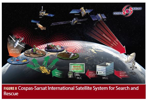
In addition to navigation services, Galileo also provides an SAR service, in the form of contribution to the International Cospas-Sarsat system, a satellite based Search and Rescue distress alert detection and information distribution system (Figure 8). Galileo satellites receive signals from Cospas-Sarsat-approved 406 megahertz emergency beacons, located anywhere on Earth’s surface and rebroadcast them in L-band to ground receiving terminals, called MEOLUTs (Medium Earth Orbit Local User Terminal), which detect and compute the distress beacon locations based on the measurements performed on the signals relayed by several SAR repeaters in visibility of the station, then report the beacon’s alert message and position to Cospas-Sarsat Operations. Galileo is one of the main contributors to the global MEOSAR alert service by providing a global space segment and the regional ground segment elements for detection/localization in Europe with three MEOLUT stations deployed in Spain, Norway and Cyprus. The management of the ground segment operations and service provision is carried out from the SAR/Galileo Service Centre located in Toulouse, France in the premises of the French National Space Agency (CNES). The SAR repeater on Galileo 5 (GSAT0201, Cospas-Sarsat designation: 418) was first switched on in December 2014. The SAR In-Orbit Testing (IOT) was performed at switch-on and the testing of the SAR repeater for Cospas-Sarsat (CS) commissioning was performed in November 2015. Followed by the testing of SAR repeater on Galileo 6 (GSAT0202, Cospas-Sarsat designation: 414) which was switched on in December 2015 and Cospas-Sarsat (CS) commissioning testing completed in March 2016. From August 2015 through February 2016 the Galileo Time and Geodetic Validation Facility (TGVF) located at ESTEC was adapted to allow the processing of Galileo satellites 5 and 6 in eccentric orbits. Orbit and clock predictions in suitable format were generated and made available on a server accessible by the European GNSS Service Centre (GSC) for subsequent dissemination to the SAR community and MEOLUTs. Adaptations of the SAR Ground Segment MEOLUT Tracking Coordination Facility (SGS MTCF) was also completed to allow the ingestion of orbital data retrieved from the GSC. The SAR repeaters on Galileo 5 and 6 were successfully tested, but not used until March 2016 due to the lack of orbital data in the navigation signal-in-space, which is essential for performing the SAR localization function. Their usage commenced when the orbital data generated by the TGVF was made available via the GSC in March 2016. This allowed MEOLUTs around the world to fetch the orbital data in order to track Galileo satellites, including Galileo 5 and 6. In the period from March 2016 until December 2016, Galileo 5 and 6 SAR repeaters have been used, together with other available Galileo SAR repeaters, for system performance validation activities and Key Performance Indicator (KPI) collection. Based on the positive results of the tests, Cospas-Sarsat considers the two repeaters commissioned and available for all users. On December 13, 2016, Cospas-Sarsat declared MEOSAR Early Operational Capability (EOC), based on commissioned MEOSAR repeaters, which included repeaters on Galileo 5 and 6 satellites and since then they are used operationally for MEOSAR by the French and US Mission Control Centers (FMCC and USMCC). With future deployment of the system, Galileo satellites will be capable of providing the Return Link Service to users with a feedback by sending an acknowledgement message to the users and informing them that the alert has been detected and eventually that rescue operations are under way. 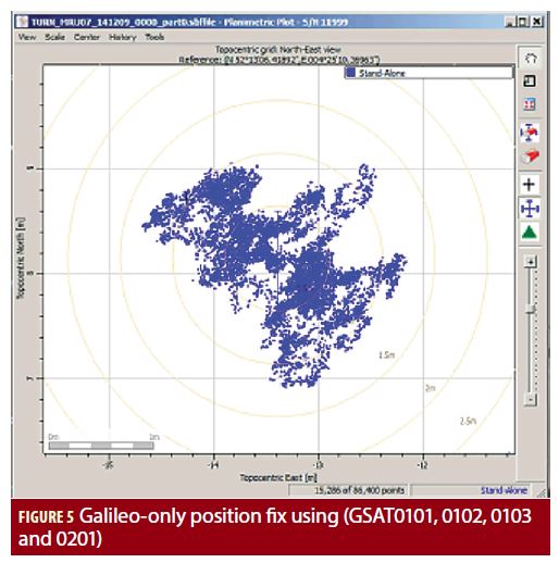
Everything is Relative
Iterating with several European scientific institutions, it became apparent from the very beginning that the recovery orbits of Galileo satellites 5 and 6, still eccentric, were, in turn, offering a unique opportunity to conduct a test of Einstein’s General Theory of Relativity by measuring more accurately than ever before the way that gravity affects the passing of time. Indeed, Einstein’s Theory of General Relativity (GR) predicts that time flows differently for two clocks that have a relative speed and are placed in different gravitational potentials. It should therefore be possible to test General Relativity by comparing the frequencies of two atomic clocks, in a so-called gravitational redshift test. A gravitational redshift experiment tests the Local Position Invariance (LPI), which is one of the aspects of the Einstein Equivalence Principle which may be tested. As several alternative theories of gravitation predict violations of this effect – e.g. in attempts to unify GR and quantum theory – experimental constraints are of paramount importance. The recovery orbits of Galileo 5 and 6 and the specificities of the Galileo satellites made these especially suitable for a Gravitational redshift tests (Figure 9), noting that: 1. Galileo 5 and 6 remain in elliptic orbits, with each satellite climbing and falling some 8,500 kilometers twice per day, and providing a periodic modulation of the gravitational redshift at the orbital period (~ 13 hours). 2. Both satellites are equipped on-board with Passive Hydrogen Maser (PHM) atomic clocks, providing unique stability. 3. Nominal satellite life time after recovery remained long (~12 years), which allows the possibility to integrate test measurements during a long time. 4. Satellites are permanently monitored with the provision of high accuracy orbits. 5. Laser Retro Reflectors (LRR) are equipped on-board the satellites which allow independent orbit tracking by laser (of high interest to disentangle clock and orbit radial errors). 6. The realization of these tests does not interfere with the potential introduction of Galileo 5 and 6 for navigation service or the nominal Search and Rescue (SAR) service. Up to date, the most precise test of the gravitational redshift has been realized with the Vessot-Levine rocket experiment in 1976 (Figure 10), also named as the Gravity Probe A (GP-A) experiment, where the gravitational redshift was verified to a level of 1.4 x 10⁻⁴ accuracy. This gravitational redshift measurement had not been improved nor reproduced at this level since then. The analysis performed showed that proper tests with the two eccentric Galileo satellites could potentially provide a more accurate test of Einstein’s General Relativity Gravitational Redshift prediction. In view of the above considerations and following the recommendations of the ESA GNSS Science Advisory Committee (GSAC), two parallel studies were launched by ESA with SYRTE/Paris Observatory and ZARM/University of Bremen in 2015. The so called GREAT project (Galileo gravitational Redshift Experiment with eccentric sATellites) aimed at measuring the Gravitational redshift predicted by Einstein General Relativity Theory with the highest possible accuracy. These tests have been performed during a period of almost three years and are now concluding. On the occasion of the ESA 6th International Colloquium on Scientific and Fundamental Aspects of GNSS / Galileo held in Valencia, Spain, from October 25-27 2017, the two parallel consortia presented some preliminary results and the methodology followed, after having assessed more than 1,000 days of data from the two eccentric Galileo satellites and properly modelled systematic errors. A careful analysis of systematic effects was essential to calculate robust limits on the gravitational redshift. All systematic effects, potentially impacting the Gravitational redshift tests, were identified and analyzed. Effects acting on the frequency of the reference ground clock or on the radio link can be safely neglected. The activity focused then on the estimate of the effects acting directly on the frequency of the on-board clock, namely temperature and magnetic field variations, and on those systematic effects linked to orbit modelling errors. Concerning systematic errors associated to the orbit modelling, a one-year dedicated Satellite Laser Ranging measurements was performed during 2016 and 2017 in close cooperation with the International Laser Ranging Service (ILRS). These allowed disentangling in a good extent systematic errors coming from the orbit and impacting the clock determination from other systematics. A major support for this activity was also received from ESA’s Navigation Office at ESOC in Darmstadt, Germany, whose experts generated the accurate clock and orbit products for Galileo satellites 5 and 6 using precise satellite models, which allowed a very accurate modelling of the non-gravitational orbit perturbations, notably from solar radiation pressure (SRP). For the other systematic errors, potentially affecting the on-board clocks, conservative upper limits were derived based on the knowledge on the satellite environmental conditions and their known effect on the frequency sensitivity of the PHM atomic clocks. 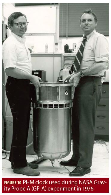 Preliminary results presented by SYRTE and ZARM at the ESA’ scientific colloquium were very positive. Both consortia did manage to confirm, in an independent way, the gravitational redshifts with accuracies slightly better than the Gravity Probe A reference. During Q1 2018, some of the orbit systematic errors have been further reduced following refinements of the orbit modelling algorithms performed by ESA’s Navigation Support Office. The new estimates are currently under final consolidation by the two consortia and it may be anticipated that results will be several times better than the GP-A Reference. Final consolidated results are planned to be submitted in a scientific journal later this year. The success of the Galileo General Relativity tests has triggered a number of additional Fundamental Physics general tests which could be performed exploiting the eccentric Galileo satellites 5 and 6 which are currently under assessment by the ESA Galileo Navigation Science Office with the support of ESA’s GNSS Science Advisory Committee. ESA also intends to make available the accurate clock and orbits processed for these two eccentric satellites to the public sometime this year for potential exploitation by the scientific community.
Conclusion
The recovery orbit of Galileo satellites 5 and 6 is compatible with the nominal Galileo constellation and some challenges due to the eccentric characteristics of the orbit have been overcome by the modifications in the ground segment. The quality of the navigation signals transmitted by these satellites have been tested and confirmed to be in line with expectations. However, all navigation signals remain flagged in “Test” mode pending the implementation of necessary measures to improve robustness of the ground segment for navigation message uplink and the deployment of on-board software for automated SIS flag setting which are required to include the satellites as part of the Galileo constellation for navigation and SAR applications. Although the SAR repeater on-board Galileo satellites 5 and 6 are already part of the SAR Initial Service contributing to the Cospas-Sarsat Program, the setting of SIS flags to “Healthy” would also have positive benefits to the SAR Service since it would allow the signals to be processed by the Galileo receivers installed in the SAR ground segment. This would make the Galileo SAR repeaters available to all MEOLUTs worldwide, without requiring those MEOLUTs to retrieve the orbital data from the server made available by GSA for this purpose. The most accurate measurements ever of Einstein’s predicted General Relativity gravitational shift were made possible thanks to Galileo, transforming an unfortunate difficult situation into an excellent scientific opportunity with further potential exploitation by the scientific community. The Galileo satellites 5 and 6 which were almost considered lost back in the summer of 2014 put under test the ingenuity of the many engineers involved in the recovery of this mission, thus demonstrating the technical excellence and collaborations with experts from various institutions, space agencies and industrial partners. Updates on the extraordinary journey of Galileo satellites 5 and 6 can be followed in future editions of Inside GNSS, featuring the final detailed results of Einstein’s General Theory of Relativity, the GREAT project and their ultimate quest towards the provision of navigation service.
Acknowledgements
The success of Galileo 5 and 6 mission recovery and exploitation would not have been possible without the excellent team effort and technical expertise across European institutions, space agencies and industrial partners. The authors would like to thank: • OHB satellite manufacturer and SSTL payload manufacturer • Airbus Defence and Space (ADS), the Ground Control Segment contractor • Thales Alenia Space, the Ground Mission Segment contractor and system engineering support • SpaceOpal, the Galileo Service Operator • French (CNES), Italian (ASI), German (DLR) and British (UKSA) space agencies experts for the support on the mission recovery plan • SYRTE, Observatoire de Paris, the GREAT consortium • ZARM, University of Bremen, the GREAT consortium • International Laser Ranging Service (ILRS) • The European Commission (EC) • The European GNSS Agency (GSA) Exploitation and Market Development Teams • The entire ESA Galileo Project Team, ESA Navigation Science Office and ESA Navigation Support Office Additional Resources 1. H. Côme et al. “GALILEO 5 and 6 LEOP or How to Handle and Recover Two of the Most Feared Failures Occurring Simultaneously,” SpaceOps Conference, 16 – 20 May 2016, Daejeon, Korea 2. A. Ayala et al. “Galileo Extended Slots Characterisation and Relation with the Nominal Constellation,” International Symposium on Space Flight Dynamics (ISSFD), 6 – 9 June 2017, Matsuyama, Japan 3. P. Delva et al. “Test of the gravitational redshift with stable clocks in eccentric orbits: application to Galileo satellites 5 and 6,” Journal on Classical and Quantum Gravity, Volume 32, No. 23 (2015) 4. R. F. C. Vessot and M. W. Levine. “A test of the equivalence principle using a space-borne clock.” Journal on General Relativity and Gravitation, Volume 10, No. 3 (1979), pp. 181 – 204 5. P. Delva et al. “An SLR campaign on Galileo satellites 5 and 6 for a test of the gravitational redshift – the GREAT experiment”, Proceedings of the ILRS Technical Workshop, 26 – 30 October 2015, Matera, Italy. 6. P. Delva et al, “Testing the gravitational redshift with eccentric Galileo satellites,” 6th International Colloquium of Scientific and Fundamental aspects of Galileo / GNSS, 25 – 27 October 2017, Valencia, Spain 7. S. Hermann et al., “Galileo Gravitational Redshift test with eccentric satellites”, 6th International Colloquium of Scientific and Fundamental aspects of Galileo / GNSS, 25 -27 October 2017, Valencia, Spain
Authors
Nityaporn Sirikan is the Galileo Signal In Space Service Provision System Engineer in the Directorate of Navigation based at the European Space Agency (ESA) – European Space Technology and Research Centre (ESTEC) in Noordwijk, The Netherlands. Hervé Côme was the ESA Service Manager for the Galileo LEOP service (Launch 3 – 8) and was the lead Flight Operations Director for Launch 3 LEOP (Galileo satellites 5 and 6). He is working in the Directorate of Operations based at the ESA’s European Space Operations Centre (ESOC) in Darmstadt, Germany. Igor Stojković is the Principal Search and Rescue (SAR) Engineer in the Directorate of Navigation based at ESA – ESTEC in Noordwijk, The Netherlands. Javier Ventura-Traveset is the Head of the Navigation Science Office and the Executive Secretary of ESA’s GNSS Science Advisory Group leading ESA’s GNSS scientific activities based at ESA’s European Space Astronomy Centre (ESAC) in Villanueva de la Cañada, Spain. Rafael Lucas is the Galileo Services Engineering Manager in the Directorate of Navigation based at ESA – ESTEC in Noordwijk, The Netherlands. Marco Falcone is the Galileo System Manager in the Directorate of Navigation based at ESA – ESTEC in Noordwijk, The Netherlands.


