 Satellite-Based Augmentation Systems – Japan Civil Aviation Bureau
Augmentation systems are designed to improve one or more qualities of a GNSS system or systems, such as accuracy, robustness, and signal availability.
Augmentation systems are designed to improve one or more qualities of a GNSS system or systems, such as accuracy, robustness, and signal availability.
Probably the most important of these are satellite-based augmentation systems (SBAS), but they also include ground-based systems, such as Australia’s Ground-Based Regional Augmentation System (GRAS), Russia’s proposed differential correction and monitoring service, and the U.S. Nationwide Differential Global Positioning System (NDGPS).
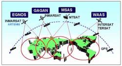
Satellite-based augmentation systems (SBASes) augment core satellite constellations by providing ranging, integrity and correction information, which increase accuracy, reliability, and availability of GNSS positioning. SBAS information is broadcast via transponders on geostationary satellites in the same band as the core constellations.
The elements of an SBAS system typically include a network of ground reference stations that monitor satellite signals; master stations processing reference stations data and generating SBAS signals, and uplink stations to that transmit the messages to the geostationary satellites.
Several commercial SBAS systems are providing services to users, including OmniSTAR (Fugro, The Netherlands), Starfire (NavCom Technology, United States), and Veripos (Subsea 7, United Kingdom).
Four non-commercial SBASes are currently in use:
Wide Area Augmentation System (WAAS), United States.
European Geostationary Navigation Overlay Service (EGNOS), Europe.
GPS Aided GEO Augmented Navigation (GAGAN), India.
MTSAT (Multi-functional Transport Satellite) Satellite Based Augmentation System (MSAS), Japan.
Regional systems provide additional signals from satellites operating over a given geographical area that are compatible with one or more GNSS systems. Regional satellite positioning systems include:
The Indian Regional Navigation Satellite System (IRNSS) will include three satellites in geostationary orbit and four satellites in geosynchronous orbit, and will be completed in 2016. The navigation payload will operate in L5-band and S-band. The ranging payload consists of a C-band transponder.
QZSS, the Quasi-Zenith Satellite System (Japan) proposes three inclined geosynchronous orbit (IGSO) satellites operating over Japan and surrounding areas and transmitting signals that are compatible and interoperable with existing and future modernized GPS signals. The first QZSS satellite, nicknamed “Michibiki” (“show the way”), was launched on September 11, 2010. The full constellation will ultimately consist of three QZOs (inclined geosynchronous orbits) and one GEO satellite.


